Sargent Mountain
Table of Contents
Local Businesses
Sargent Mountain: Your Secluded Summit Adventure in Acadia National Park
For Acadia's big summit views without the Cadillac Mountain crowds, try Sargent Mountain. At 1,373 feet, it's the park's second-highest peak but remains under the radar. With no road to the top, it offers a quieter, more intentional hike—ideal for families. Just below the summit lies Sargent Mountain Pond, Maine's first post–Ice Age lake, formed about 16,600 years ago. Kids enjoy the folklore claiming it's "bottomless" and home to a serpent—science has disproved one, sparking fun trail debates.
Why Sargent Feels So Different: The Gift of Trail-Only Access
Just below the summit—about 300 feet down—is a small alpine pond at 1,200 feet. With no inflowing streams, its sediments stay clean, letting scientists study thousands of years of climate history. The clear, nutrient-poor, acidic water is completely fishless—much to kids' surprise. Local lore claims it's "bottomless" and home to a serpent; one story has been debunked, but the mystery adds magic, especially when fog drifts over the surface. It's an easy spot for a quick, fun learning moment.
Choosing Your Route: Sargent's Best Trails for Families
One reason families love Sargent is the flexibility. You can shape the loop to match your group's energy level, whether you are hiking with teens who move quickly or younger kids who need frequent snack breaks.
North Ridge Trail
1 mile | Hard | 870 ft gain
Think of this as the "straight up the mountain" option. It's steep, rocky, and perfect for older kids or teens who love the challenge and want that instant summit reward. Not long, but it'll wake up your legs.
South Ridge Trail
2.7 miles | Medium | 1,330 ft gain
This is the trail most families choose. The grade stays manageable, the views are pleasant, and you'll pass wildflowers, granite sections, brief looks at Cedar Swamp Mountain, and a short spur to Sargent Mountain Pond. If you want a hike that feels rewarding without constant reminders to watch your step, this is a solid place to begin.
Grandgent Trail
0.6 miles | Hard | 310 ft gain
A short, challenging route suited for adventurous hikers. The scrambling and steep sections make it ideal for strong teens who like a physical test, but it's not appropriate for younger kids.
Hadlock Brook Trail
1.2 miles | Hard | 980 ft gain
A steady forest climb with a few footbridges and small waterfalls along the way. It's a beautiful route, though it requires real effort. A good fit for families comfortable with a more demanding uphill.
Maple Spring Trail
~0.43 miles | Medium
A quick, scenic connector that shows off glacier-carved bedrock and lovely Hadlock Pond views. You'll likely use it as part of a bigger loop with South Ridge or Hadlock Brook.
Giant Slide Trail (Loop)
5.7-mile loop | Challenging | 1,487 ft gain
It feels like a natural obstacle course with boulder fields, rock slides, and a few tight squeezes along the way. Kids who love climbing gyms usually think this trail is a blast. Pets aren't allowed, and the terrain is far too steep and rugged for them anyway.
Penobscot Mountain Trail
2.2 miles | Hard | 1,260 ft gain
Expansive, horizon-wide views and a clean, rocky summit. Link it with the South Ridge for a simple, satisfying two-summit day you'll remember.
What the Terrain Is Really Like
No matter which trail you choose, expect a little bit of everything:
- Forest floors with roots and rocks
- Cedar swamps and shaded brooks
- Historic stone bridges
- Slick rock after rain
- Open granite ledges near the summit
Kids often love the variety, but sturdy, closed-toe shoes with good traction are a must. Wet granite is no joke.
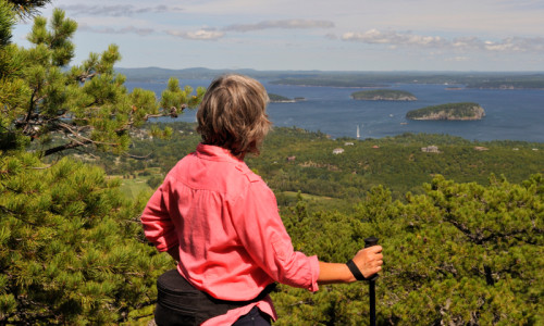
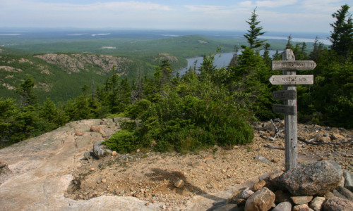
Summit Views: What You'll See From the Top
The summit delivers true 360-degree panoramas, and because it's quieter, you may have whole moments where it's just your family and the wind.
Here's what's spread out below you:
East: Cadillac Mountain and Pemetic Mountain—your best look at Acadia's iconic neighboring peaks.
Northeast: The Porcupine Islands and Frenchman Bay—a cluster of glacier-rounded islands that look like a row of porcupines resting on the water.
South: The Cranberry Isles—five peaceful islands named for their wild cranberries.
West: Somes Sound, North America's only fjard (similar to a fjord, but shallower). It nearly slices Mount Desert Island in half.
Further West: Western Mountain (Bernard + Mansell)—Acadia's quieter side and home to steep, beautiful trails like the Perpendicular Trail.
And while you can't literally see the entire Appalachian range, you are standing inside it.
Planning Your Sargent Adventure: What Families Need to Know
Timing & Safety
- Avoid starting late in the afternoon; most routes take several hours.
- Bring more water than you think you'll need.
- Carry a paper map—cell service is unreliable.
- Do a tick check afterward.
A quick parenting aside: pack snacks your kids can access without unpacking everything. Energy dips hit fast on granite.
Gear Essentials
- Sturdy, grippy hiking shoes
- Layers (summits can be windy)
- A watch (don't rely on a phone)
- Camera
- Small first-aid kit
- If you're cell-safety cautious: a satellite device
Pets
Dogs are welcome on most Sargent routes on a 6-foot leash, but anything with iron rungs, steep ladders, or giant boulder scrambles isn't pet-friendly. Always pack out waste.
Park Pass
You'll need an Acadia entrance pass from May 1–Oct 31. Display it on your dash.
Parking & the Island Explorer Shuttle
Summer parking can be tight, especially on Route 198/3 near trailheads. The free Island Explorer bus (mid-June–October) is a game-changer. Take it to Jordan Pond House or Parkman Mountain to begin your hike without stress—and without looping for parking spots while everyone grows impatient.
Stop at Hulls Cove Visitor Center
Rangers there will help you choose the best trail for your family's abilities and the day's conditions.
Final Takeaway
Sargent Mountain is Acadia's quieter giant—a place where your family can earn big views, learn a little natural history, dip into an ancient lake, and enjoy a summit without crowds. With flexible trail options, rich geology, and truly spectacular panoramas, it delivers that "we found our spot" feeling that families talk about long after the trip ends.